To all Wardour Residents: This is a work in progress shared with us by a past president of the WIA. Any further information, especially from the lawyers concerning the gray areas, will be welcome.
The community known as Wardour currently comprises about one hundred homes and about one hundred acres on two “Wardour” plats and five additional homes on a third “Wardour” plat. What we have in common, in addition to the name, are the prior and independent rights of the owners on the first two plats to use most of the properties on the three plats to which the Wardour Improvement Association (“the WIA”, “the Association”) now holds the deeds.[1] Wardour boundaries (and the voting rights of owners and of tenants) are defined in our Constitution, and uses of the Association properties are defined primarily in our Declaration.[2] (Other matters are left to the Bylaws and Standing Orders.)
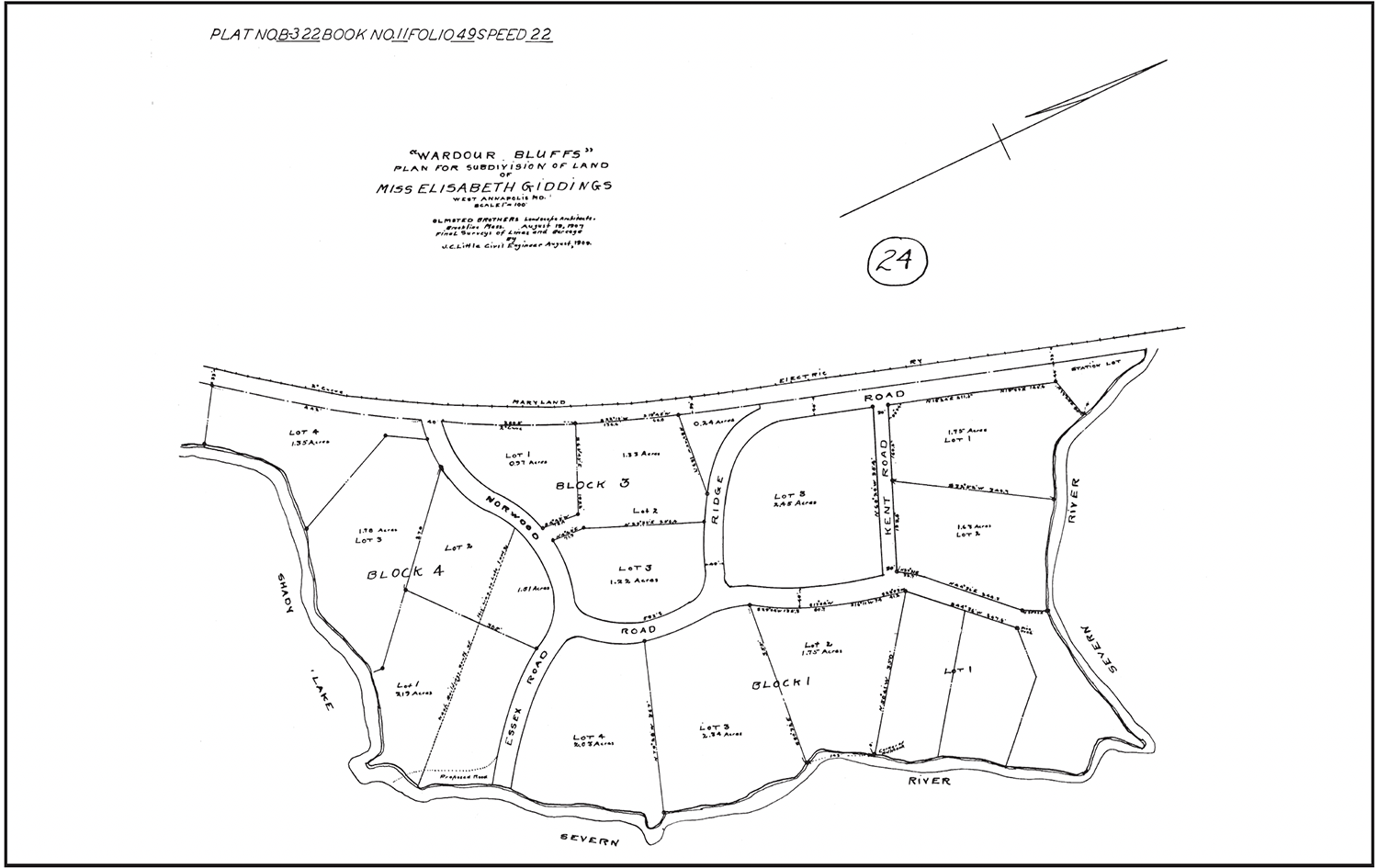
1907—Wardour Bluffs
In 1907 Wardour Bluffs was surveyed and platted (plat recorded in 1909) for Elizabeth Giddings by the Olmstead Brothers, distinguished landscape architects (pictured above)[3]. She retained title to the streets with a deeded right of use by all lot owners and, until 1926 (perhaps because the roads on the original plat were not marked as private), individual right of use by anyone else who chose to accept them.
Two of the roads ended at the Severn River: (1) At that time what is now number 1 Norwood Road was shown not as a buildable lot but as a widening of the end of Norwood Road at the river and was used as a bathing beach mostly by residents of Wardour and West Annapolis until 1936, since which time only the forty feet of the road remain open to the community; (2) The Severn River end of Essex Road.
Wardour Bluffs was immediately downriver from a right of way then belonging to the Maryland Electric Railway, acquired by the latter’s predecessor, the Annapolis and Baltimore Short Line Railroad Company, from Elizabeth Giddings and her sister, Catherine Aldridge, in 1886.
1915—Wardour on the Severn River
In 1915 Wardour on the Severn River on the upriver side of the railway was surveyed and platted for Miss Giddings by the Olmstead Brothers[4]. Again Miss Giddings retained title to all roads to which, again, lot owners had a deeded right of use, and, again, other individuals could until 1926 acquire such rights simply by using the roads. This plat, too, included two roads ending at the water: (1) What is now Wardour Drive ending at the Severn River slightly upriver from the railroad right of way, and (2) Westwood Road ending at Weems Creek.
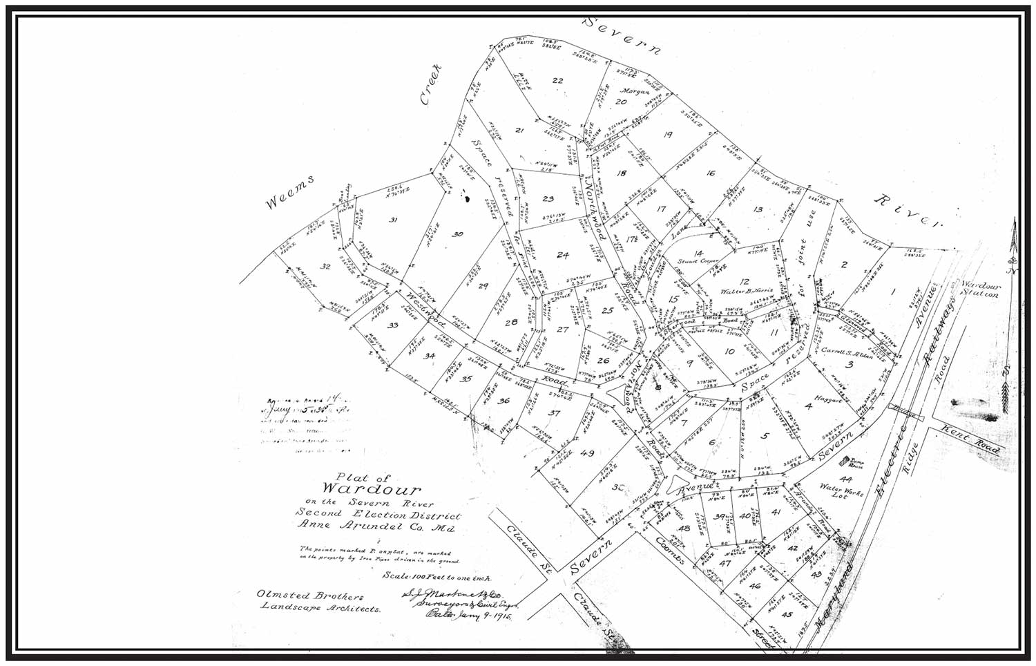
In addition, the 1915 plat shows two waterfront-access areas marked “Reserved for Joint Use”, title retained by Miss Giddings, with deeded rights of use by lot owners but no one else. One of them, now called the Wardour Reserve, arises near Wardour Circle and ends at the Severn River at what is now known as Gudger Beach. The other access, now called the Westwood Reserve, arises on Westwood Road and ends at Weems Creek and is not currently in use, though it has been heavily used in the past. It has been suggested that each reserved strip pertains only to those properties actually adjoining it and not to other lots on the same plat; it does not appear that any such restriction has ever been enforced against other Wardour lot owners.
Also in 1915, and at the suggestion of Miss Giddings, who lived at 100 Old Crossing Road, the Wardour Improvement Association was founded and incorporated. Its boundaries were not stated. (Elizabeth Giddings was not one of the incorporators but her nephew Robert G. Aldridge was.)
The property at 20 Wardour Drive, a part of what used to belong to the old Wardour Water Company, extends (just wide enough for pipes) to the Severn River, separating Wardour Drive and Wardour Beach from the former railroad right of way. Recent and current owners have permitted us to cross from Wardour Beach to the Wardour Overlook and Crescent Beach. Without that permission we would have to clear and use Ridge Road from Kent Road to Crescent Beach (Station Lot).
1924, 1926—Turnover and Revocation
In 1924 Charles Lee, a developer, acquired from Elizabeth’s Giddings’s estate all of her properties in what is now known as Wardour.[5] In 1926 he revoked the implied permission for open use of the roads on both plats to anyone caring to use them, and formally deeded almost all of them except the four waterfront street ends to the County Commissioners[6]. (Some other streets that he didn’t deed, all inland, have occasioned a few questions involving responsibility for paving.) The revocation did not affect the rights of deed holders or of any other individuals (mostly West Annapolis residents) who had already made use of the streets, including street-ends at the water, of Wardour.[7]
1927—Wardour Plat No. 2
In 1927 Lee filed a plat[8] titled Wardour Plat No. 2, which overlapped some of what was already included in the 1915 plat—105 Scott Drive, the inland side of Westwood Road, and the inland side of Wardour Drive from the Triangle to the Circle—and added properties on Scott Drive and Claude, Monterrey, and Monroe (now Shiley) Streets. Why he overlapped the 1915 plat we do not know, but it is possible that he felt it gave some authenticity to his use of the name Wardour on the plat and deeds even though it was not an Olmstead Brothers project, thus increasing the sale values of his other properties. Association records show no reaction, positive or negative, to this event.
Lee also drew a strip marked simply “Reserved” running from Scott Circle down to Weems Creek, and now known as the Scott Reserve; our current legal advice is that this did not mean “Reserved for Joint Use” of lot owners on the plat but rather signaled that it was reserved solely for the owner, Lee, and now the Association.
(Some time after 1974 someone planted protected species on the Scott Reserve, making it unusable by anyone for any purpose under current law.)
There are many beautiful homes and cozy cottages in Wardour No. 2, but it is not an Olmstead Brothers development and its housing is too dense to share Wardour’s R1A zoning. At this writing it appears unlikely that the rest of its residents (that is, those not already on the 1915 plat) will be invited to membership in the Association. An internal suggestion that they be encouraged to form a West Wardour Association (Scott Circle is due west of Wardour Circle) to which the Association might then make the Scott reserve available has not been well received in Wardour, and Wardour No. 2 residents have therefore not been asked for their opinions.
1936—Title and Boundary Changes
In 1936 Lee deeded the reserved properties, his remaining streets on the three plats, and a small lot identified as Station Lot (now called “Crescent Beach”) beside the railroad on the 1907 plat[9], to the Wardour Improvement Association.[10] At that time, and presumably for that reason, the Association adopted a boundary resolution extending the boundary (never previously defined) along the Weems Creek side of Scott Drive to the Reserved strip. At some time or times after 1974 the boundary was further extended to include the entire Weems Creek waterfront of Scott Drive and is now so defined in the WIA Constitution.
1948—Alienation and Acquisition at Ridge Road
In 1948 the owner of 2 Kent Road contracted with the Association to acquire that section of Ridge Road running beside his property on the 1907 plat from Kent Road to the present ending of lower Ridge Road at what is now a circle near Norwood. (The upper section of Ridge Road from Kent Road to the Station Lot remained.) One other family was involved in the swap and the Association thereby acquired some land that made the circle possible. It is said that the owner of 2 Kent Road obtained the consent of all the owners fronting on Ridge Road—that is, everyone who might have wanted to use the deeded section. Aside from satisfying natural curiosity about why the current map differs from the 1907 plat, this paragraph calls attention to what appears to have been the only alienation of WIA common property. This event caused a great deal of hard feeling at the time among those owners who were not parties to the agreement.[11]
1983–The Railroad Right of Way
In 1983 the Baltimore & Annapolis Railroad, eventual successors to the Maryland Electric Railway, deeded to the Association its right of way extending from the Severn River between our 1909 and 1915 plats to Old Crossing Lane and (now with interruptions) all the way to Annapolis Street in West Annapolis[12]. An intended minimum of sixty-six feet wide, it was a significant addition to the Association’s acreage. It is increasingly in use near the river as an Overlook and as a good place for Association meetings. It forms a grade crossing where Old Crossing Lane become Norwood Road, and the entrance there has to be kept accessible to BG&E, which has an easement. The intersection is commonly called Norwood Crossing but no convenient name, such as Wardour Way, has been adopted for the rest of the former railroad right of way itself. Beyond Wardour, a stretch of the right of way was acquired by adverse possession by the Wardour Bluffs apartments, and two stretches were sold to West Annapolis residents.
The Present
The Association has no plans either to increase or decrease its land holdings, with the possible exception of those stretches of the former railroad right of way lying wholly outside Wardour.[13] We are considering installing floating docks at one or more of the waterfronts, and making more use of the right of way beyond the Overlook toward Old Crossing Lane.
Use of WIA properties has varied over the years, and we have mostly left maintenance in the hands of the actual users. In the interests of preserving and enhancing our property values we have recently been paying more attention to the grooming of all the properties.
Other Sources[14]
There are or will be separate website articles on the early history of the area and the history of the Association. The three original plats, a contemporary map of Wardour, and a list of relevant deeds are or will be elsewhere on the site along with our original Constitution and Bylaws of 1915, our current Constitution and Bylaws, and our Declaration of Easements, Covenants, Conditions, and Restrictions.
[1] Of the twelve WIA properties (or thirteen, counting the two segments of Ridge Road separately) seven (or eight) are “common” in the sense that holders of deeds have certain rights on those properties independently of who holds the title, but the WIA also owns outright five properties that should not be referred to as common properties—deed holders have only such rights there as the Association gives us, and they can be disposed of without infringing on any deed holders’ rights.
Three of the Association properties which are not common properties are the waterfront Station Lot (now called Crescent Beach) on the 1907 plat of Wardour Bluffs, most of a cul de sac at what is now the upper end of lower Ridge Road near Norwood Road in Wardour Bluffs, and the waterfront Reserved strip at Scott Circle on the 1927 plat. A fourth property is the former railroad right of way separating the 1907 and 1915 plats and extending with interruptions to Annapolis Street (this is not on any of the plats, but much of it is between two of the plats and is therefore in a sense within Wardour). The fifth property is the bridge over the former railroad right of way connecting Kent Road to Wardour Drive (not on either plat), including about ten feet each of land on both sides (?) and at both ends. Although we are allowed to maintain Wardour Circle and the Triangle, they are City property (9/18/35 Deed from Lee to Co. Comm.).
The Association can give permission for the use of the street end waterfronts on each plat to residents of the other plats, and to anyone else, for that matter—residents of West Annapolis, for example. This is true also of the Scott Circle reserved strip and the other properties which are exclusively the Association’s—the Association can make them available to anyone.
[2] A Declaration of Easements, Covenants, Conditions, and Restrictions is required by state law as a condition of property tax exemption and is recorded in the county land records. Our seven-page Declaration acknowledges prior property rights by deed, lists some rules, and provides that the WIA Executive Committee may make other rules. Essentially, residents may use WIA property, both common and exclusive, without interfering with other residents’ right of use, but may not erect structures or do any landscaping thereon without permission.
[3] 1909 Plat Book No. B-322 Book 11 Folio 49 Speed 22 1907 Plat of Wardour Bluffs
[4] 1915 553A Plat of Wardour on the Severn River
[5] 1924 WNW 73 363 Giddings estate to Charles Lee by Fitzhugh, Trustee
[6] 1926 WNB 19 458 Most Wardour streets (no waterfront street-ends) to County Commissioners by Lee
[7] It is sometimes asserted that “Miss Giddings meant for the people of West Annapolis to use the beach”; the wording of the plats shows only that she did not intend to exclude anyone. That ended in 1926 with Lee’s revocation, but those individuals who had already accepted the roads, including street ends at water, retained their right of use. Possibly for this reason there seems to have been no immediate attempt to distinguish Wardourians and West Annapolitans in this context. In 1936 Lee designated all of the Norwood Road beach (“Horseshoe Point”) except forty-foot wide Norwood Road itself as a buildable lot, now 1 Norwood Road, and the Severn River end of Wardour Drive became the swimming beach. The Association then and for some years operated a swimming beach at Wardour Beach with a bonded, deputized guard and charged West Annapolitans and some others a fee to use it. The Association has a Wardour beach tag from 1952 which belonged to a Homewood resident.
[8] 1927 Plat No 348 Plat Book No. 6 Folio 46 Plat of Wardour No. 2. This was a misnomer–there was no “Wardour [No. 1],” and as we have seen there were two other plats merely containing the word “Wardour.”
[9] 1936 FAM 153, 169,170 Lee to WIA some streets, waterfront street-ends, and reserved areas on all three plats.
[10] This made a little-noticed but possibly significant change in the status of the WIA. Previously the Association presumably could have represented the interests of the deed holders against the owner of record. For example, if Giddings or Lee had proposed plantings of a protected species in a reserved area, thereby (had the law been as it is now) making the area unusable by anyone, the Association could have represented the deed holders against the owner. But now the WIA is the owner and its Executive Committee recently proposed exactly that action. Strenuous objection by individual members of the Executive Committee helped to prevent it. (Endnote 11 also relates to this question of the Association’s rights and duties.)
[11] It has been suggested that other deed holders on the 1907 plat could have blocked the sale of the Ridge Road segment, but that after twenty years it became incontestable. Some residents resigned from the Association because they believed that the Association had a duty to preserve everyone’s right of use and that they might become liable for the loss. (See also Endnote 10.) The episode is emphasized here as a caution for future proposals to dispose of any truly common property.
[12] 1983 Liber 3681 Folio 725
[13] Where the 1915 plat stops at Old Crossing Lane, the 1907 plat continues another 442 feet S by W and we regard the adjacent part of the former right of way as being within Wardour (although as far as zoning is concerned it is presumably in West Annapolis along with all the rest of that right of way). We have no clear policy regarding the stretches beyond that to Annapolis Street that still belong to us. One stretch was lost to an apartment complex by adverse possession and two other parts were deeded to homeowners in West Annapolis.
[14] For future reference and presumably eventual deletion of this footnote, here are two citations I’ve never checked.
1892 SH 41 131 ?
1905 GW 46 ?